Scenic Drives: Final Report
 Alright.
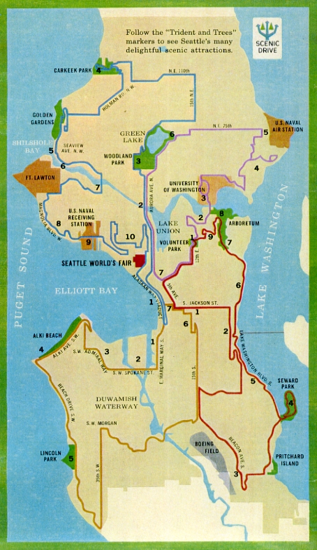
I've now driven all 117 miles of the four original Scenic Drives laid out around Seattle in 1958, as depicted by this map. Other than along the mustard-colored Scenic Drive 4, I didn't see a single "Scenic Drive" sign on any of the other drives.
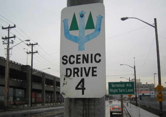
However, I did receive Seattle DOT's work report dated March 5, 1981, addressing the original 94 wooden signs installed along Scenic Drive 4 in '58. In '81, 35 signs were replaced (23 of which were "weathered," 11 of which were "missing," and one of which wasn't described at all). Five signs were removed (or six, if you count the one with the zen-inducing instruction to "remove missing"). The instruction for sign #29 says "Trim shrubs or RESET post and REPLACE," though I'm not sure which one happened. Two were marked "OK," and apparently left alone.
The other 50 signs weren't individually mentioned or field-checked, as the abridged 1981 route no longer included them. Instead, 18 new signs were installed along new legs of the shortened route -- four "temporary," and 14 permanent.
Eliza and I did our own field-checking in the last few weeks, finding just 13 signs still posted today. We came across both wooden and metal signs -- my best guess is that the original wooden signs were replaced with similarly wooden signs in 1981, but since then were replaced as needed with metal signs. Below is a list of the ones we found, with links to area maps. The signs are numbered according to the '81 report.
3. On the west side of Alaskan Way S at S Royal Brougham Way, facing north. Map.
21. On the east side of California Avenue SW, just north of SW Donald Street, facing south. Map.
25. On the north side of Harbor Avenue SW where it turns into Alki Avenue SW, facing southeast. Map.
31. On the west side Beach Drive SW, just north of SW Andover Street, facing north. Map.
33. On the west side Beach Drive SW, just north of SW Juneau Street, facing north. Map.
34. On the west side Beach Drive SW, just north of Lincoln Park Way SW, facing north. Map.
35. On the southwest side of Lincoln Park Way SW, just east of Beach Drive SW, facing northwest. Map.
39. On the south side of Wildwood Place SW at Fauntleroy Way SW, facing north. Map.
40a. On the south side Wildwood Place SW at 45th Avenue SW, facing northwest. Map.
40b. On the east side of California Avenue SW where it turns into SW Barton Street, facing south. Map.
51f. On the east side of the Alaskan Way Viaduct, just north of West Seattle Freeway, facing south. Map.
51i. On the south side of the Alaskan Way Viaduct off-ramp to Seneca Street, just west of First Avenue, facing west. Map.
51j. On west side of First Avenue S at S Cherry Street, facing north. Map.
Previous Scenic Drive posts:
Seattle's Scenic Drive to Nowhere
Follow the Trident and Trees
Signs, Signs, (Not) Everywhere a Sign
Scenic Drives Update
***
Labels: Scenic Drives
posted by Steve @ 6:55 PM
2 Comments
![]()
![]()
2 Comments:
Do you have an actual mapping of the 117 miles of these routes?
Hi Rhonda -
I just followed the routes seen on this map:
http://www.stevemandich.com/uploaded_images/blogscenicdrive2-778951.jpg
- Steve
Post a Comment
Subscribe to Post Comments [Atom]
<< Home